 Preliminary
GIS total station
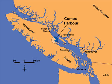
mapping of exceptionally well-preserved intertidal wood-stake fish trap
features at Comox Harbour, along the east coast of Vancouver Island,
British
Columbia, suggests an intensive fishery (1230-120 BP) using mass
harvesting technologies. The large sizes, shapes and numbers of these
archaeological features appear to be unique for the Northwest Coast,
and they hold potential for an expanded interpretation and
understanding of fishing technology in the region.
Preliminary
GIS total station
mapping of exceptionally well-preserved intertidal wood-stake fish trap
features at Comox Harbour, along the east coast of Vancouver Island,
British
Columbia, suggests an intensive fishery (1230-120 BP) using mass
harvesting technologies. The large sizes, shapes and numbers of these
archaeological features appear to be unique for the Northwest Coast,
and they hold potential for an expanded interpretation and
understanding of fishing technology in the region.
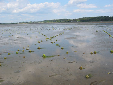 The
features can been seen in concentrations of complex, overlapping
alignments of wood-stake remains on the surface of the tidal flats, as
clearly seen in the photograph to the right. More than 200 locations of
these
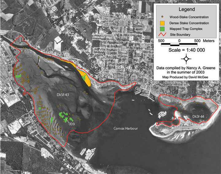
concentrations have been GPS mapped in two previously unrecorded archaeological
sites (DkSf-43 and DkSf-44) in the harbour. Eleven of these
concentrations of wood stake remains were selected from a range of
tidal elevations for further mapping. To date, over 11,000 individual
wood stakes have been mapped with a total station, a small percentage
of the well-preserved
wood-stake remains that are extensively distributed on the mudflats.
The
features can been seen in concentrations of complex, overlapping
alignments of wood-stake remains on the surface of the tidal flats, as
clearly seen in the photograph to the right. More than 200 locations of
these
concentrations have been GPS mapped in two previously unrecorded archaeological
sites (DkSf-43 and DkSf-44) in the harbour. Eleven of these
concentrations of wood stake remains were selected from a range of
tidal elevations for further mapping. To date, over 11,000 individual
wood stakes have been mapped with a total station, a small percentage
of the well-preserved
wood-stake remains that are extensively distributed on the mudflats.
 Current
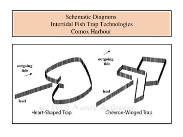
total station mapping and radiometric dating of wood stake remains
suggest two temporally distinct feature types, or structural designs,
of tidal fish trap technology, as shown in the illustration to the
left.
Current
total station mapping and radiometric dating of wood stake remains
suggest two temporally distinct feature types, or structural designs,
of tidal fish trap technology, as shown in the illustration to the
left.
The older technology appears to be represented by large heart-shaped enclosures with a flattened, or truncated, rear wall, with an opening toward the shoreline, and aligned with the outgoing tide. The younger technology is represented by numerous, large chevron-winged enclosures, likewise with openings toward the shoreline. Both technologies appear to have functioned using leads.
 Complex
009 is an
example of the total station-mapping of individual wood stakes within
one of the GPS-mapped concentrations on the tidal flats. The single
heart-shaped feature,
with a diameter of about 42 meters, was 14C dated at 1,070 yr BP. The
chevron-winged
technology is represented by at least four temporally distinct
overlapping trap structures. The two separate enclosures of one of the
chevron-winged structures have been dated at 220 yr BP and 230 yr BP,
respectively, confirming that the elements are temporally associated
and likely functioned in combination to catch fish.
Complex
009 is an
example of the total station-mapping of individual wood stakes within
one of the GPS-mapped concentrations on the tidal flats. The single
heart-shaped feature,
with a diameter of about 42 meters, was 14C dated at 1,070 yr BP. The
chevron-winged
technology is represented by at least four temporally distinct
overlapping trap structures. The two separate enclosures of one of the
chevron-winged structures have been dated at 220 yr BP and 230 yr BP,
respectively, confirming that the elements are temporally associated
and likely functioned in combination to catch fish.
Mapping, radiometric dating, analysis of features, and analysis of fish species potentially harvested in these large traps are ongoing.